Railroad Maps
The construction of railroads shaped the United States in a way that no other nation has been shaped. Charters and land grants impacted the patterns and timing of settlement and farming by emigrants. The checkerboard pattern of railroad grant lands can still be seen on maps of areas in the United States West. The fortunes and destinies of towns and villages were determined by a railroad passing through or by-passing population clusters. Towns passed by often dried up or were moved to a more optimal railroad location. The transcontinental lines, once constructed and connected, tied the East to the West in a way that was faster than horse-drawn wagons and more direct than ships sailing around Cape Horn through the Straits of Magellan.
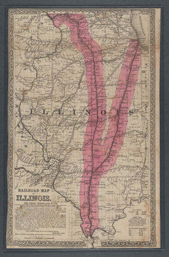
Chicago was at the heart of the United States railroad network as a connection between the eastern United States, the Great Lakes, the Mississippi River, and the western lands beyond the Mississippi. Illinois was decidedly shaped by railroads converging on Chicago but also by deliberate construction paths such as the Y created by the Illinois Central Railroad (see illustration).
Railroad maps served as trip-planning tools, company advertisements, and immigrant recruiters. This collection includes railroad maps of Illinois, the United States, and North America published during the 19th and 20th centuries.
Railroad lines often appear on “general” maps, some of which can be found in the Historical Maps Online collection at (https://go.library.illinois.edu/HistoricalMapsOnline). Additionally, aerial photography, indexes which can be found in the Aerial Photograph Indexes digital collection (https://go.library.illinois.edu/AirPhotoIndexMaps), are an excellent way to examine railroad structures such as roundhouses and switching yards.
Please contact the Map Library regarding these items via e-mail at charts@library.illinois.edu or by calling 217-333-0827.