
Nouvelle Carte Forestière de l'Algérie indiquant la division territoriale civile et militaire par Provinces et Départements...
Permalink
https://digital.library.illinois.edu/items/0cacc8c0-6c98-0134-1deb-0050569601ca-6
This item is in the public domain.
Descriptive Information
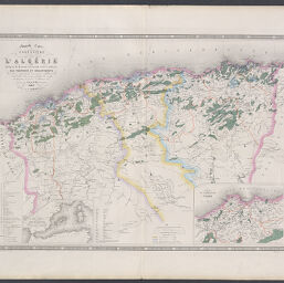
| Title | Nouvelle Carte Forestière de l'Algérie indiquant la division territoriale civile et militaire par Provinces et Départements... |
| Creator | Vuillemin, A. (Alexandre), 1812- |
| Date | 1875 |
| Dimensions | 56 x 77.5 cm |
| Place of Publication | Paris (France) |
| Cartographic Scale | 1:1,360,000 |
| Coverage-Spatial | Africa, North |
| Genre | Maps |
| Language | French |
| Source | A. Logerot |
| Physical Location | Professor Thomas Bassett Personal Collection |
| Map ID | afm0002425 |
| Rights | No Copyright - United States |
| Rights Description | This item is in the public domain. |
| Collection Title | Maps of Africa to 1900 |
| Repository | Rare Book & Manuscript Library |
| Type | Cartographic material |
| Collection | Maps of Africa to 1900 |
Download Options
|
Nouvelle Carte Forestière de l'Algérie indiquant la division territoriale civile et militaire par Provinces et Départements... |
Contact us
for questions and to provide feedback.