
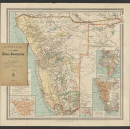
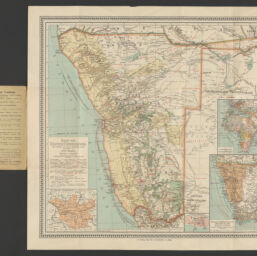
Karte von Deutsch-Südwestafrika nach amtlichen und anderen verlässlichen Ouellen
Permalink
https://digital.library.illinois.edu/items/16e05a40-b749-013d-5129-02d0d7bfd6e4-6
This item is in the public domain.
Descriptive Information
| Title | Karte von Deutsch-Südwestafrika nach amtlichen und anderen verlässlichen Ouellen |
| Alternative Title | Deutsch-Südwestafrika |
| Creator | Herkt, Otto |
| Contributor | |
| Date | 1903 |
| Extent | 1 map : color |
| Dimensions | 46 x 51 cm, folded in cover 19 x 13 cm |
| Place of Publication | Głogów (Województwo Dolnośląskie, Poland) |
| Publisher | Carl Flemming, Verlag |
| Cartographic Scale | 1:3,000,000. 1 mm der Karte = 3 km in der Natur |
| Cartographic Coordinates | (E 11°15ʹ--E 25°32ʹ/S 16°43ʹ--S 29°25ʹ) |
| Notes |
|
| Coverage-Spatial | Namibia |
| Subject | Transportation |
| Genre | Maps |
| Call Number | G8620 1903 .H47 |
| Rights | No Copyright - United States |
| Rights Description | This item is in the public domain. |
| Collection Title | Maps of Africa to 1900 |
| Repository | Rare Book & Manuscript Library |
| Type | Cartographic material |
| Bibliographic Identifier | 99955571809305899 |
| Collection | Maps of Africa to 1900 |
Download Options
|
99955571809305899-00000001 | |
|
99955571809305899-00000002 | |
|
99955571809305899-00000003 |
Contact us
for questions and to provide feedback.