
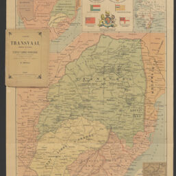
Le Transvaal (République sud africaine) et l'Etat Libre d'Orange: carte physique, politique et minière d'après les documents les plus récents
Permalink
https://digital.library.illinois.edu/items/171d3f50-b749-013d-5129-02d0d7bfd6e4-d
This item is in the public domain.
Descriptive Information
| Title | Le Transvaal (République sud africaine) et l'Etat Libre d'Orange: carte physique, politique et minière d'après les documents les plus récents |
| Alternative Title | Carte du Transvaal (République sud africaine) et de l'Etat Libre d'Orange |
| Creator | Zerolo, Elías |
| Contributor | |
| Date | 1899 |
| Extent | 1 map : color |
| Dimensions | 52 x 49 cm, on sheet 73 x 56 cm, folded in cover 19 x 15 cm |
| Place of Publication | Paris (France) |
| Publisher | Garnier frères |
| Cartographic Scale | 1:2,000,000 |
| Cartographic Coordinates | (E 18°50ʹ--E 28°40ʹ/S 21°49ʹ--S 31°00ʹ) |
| Notes |
|
| Coverage-Spatial | |
| Subject | Free State |
| Genre | Maps |
| Language | French |
| Call Number | G8503.T7 1899 .Z4 |
| Rights | No Copyright - United States |
| Rights Description | This item is in the public domain. |
| Collection Title | Maps of Africa to 1900 |
| Repository | Rare Book & Manuscript Library |
| Type | Cartographic material |
| Bibliographic Identifier | 99955571888105899 |
| Collection | Maps of Africa to 1900 |
Download Options
|
99955571888105899-00000001 | |

|
99955571888105899-00000002 | |
|
99955571888105899-00000003 | |

|
99955571888105899-00000004 |
Contact us
for questions and to provide feedback.