
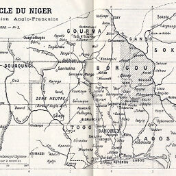
Boucle du Niger Convention Anglo-Français
Permalink
https://digital.library.illinois.edu/items/208000d0-e946-0133-1d3d-0050569601ca-5
This item is in the public domain.
Descriptive Information
| Title | Boucle du Niger Convention Anglo-Français |
| Creator | Société de Géographie de Toulouse |
| Date | 1898 |
| Dimensions | 14.8 x 22.3 cm |
| Place of Publication | France |
| Cartographic Scale | 1:5,750,000 |
| Coverage-Spatial | Dahomey |
| Subject | |
| Genre | Maps |
| Language | French |
| Color | Bitonal |
| Technique | Lithography |
| Source | Bulletin de la Société de Géographie de Toulouse, V. 17, between pp. 304-305. |
| Physical Location | stx |
| Map No. in Bassett and Scheven Bibliography | 2385 |
| Call Number | 910_6SOCT |
| Map ID | afm0002385 |
| Rights | No Copyright - United States |
| Rights Description | This item is in the public domain. |
| Collection Title | Maps of Africa to 1900 |
| Repository | Rare Book & Manuscript Library |
| Type | Cartographic material |
| Collection | Maps of Africa to 1900 |
Download Options
|
Boucle du Niger Convention Anglo-Français |
Contact us
for questions and to provide feedback.