
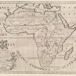
New Map of Libya or Old Africk
Permalink
https://digital.library.illinois.edu/items/20d49d50-e946-0133-1d3d-0050569601ca-c
This item is in the public domain.
Descriptive Information
| Title | New Map of Libya or Old Africk |
| Creator | Wells, Edward, 1667-1727 |
| Date | 1700 |
| Dimensions | 37.1 x 49.4 cm |
| Place of Publication | England |
| Cartographic Scale | 1:25,000,000 |
| Coverage-Spatial | Africa |
| Genre | Maps |
| Language | English |
| Source | A treatise of antient and present geography, plate 36. |
| Physical Location | rbx and loose sheet: G8300170-S6 |
| Map No. in Bassett and Scheven Bibliography | 50 |
| Call Number | X910W46T1706 |
| Map ID | afm0000050 |
| Rights | No Copyright - United States |
| Rights Description | This item is in the public domain. |
| Collection Title | Maps of Africa to 1900 |
| Repository | Rare Book & Manuscript Library |
| Type | Cartographic material |
| Collection | Maps of Africa to 1900 |
Download Options
|
New Map of Libya or Old Africk |
Contact us
for questions and to provide feedback.