
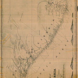
Map of Liberia
Permalink
https://digital.library.illinois.edu/items/20ebd070-e946-0133-1d3d-0050569601ca-1
This item is in the public domain.
Descriptive Information
| Title | Map of Liberia |
| Creator | American Colonization Society |
| Date | 1892 |
| Dimensions | 42.5 x 59 cm |
| Place of Publication | United States |
| Cartographic Scale | 1:900,000 |
| Notes | Relief shown by hachures, depths shown by soundings. Includes elevation profiles of 5 mountains. |
| Coverage-Spatial | Liberia |
| Subject | |
| Genre | Maps |
| Language | English |
| Color | Bitonal |
| Technique | Etched or engraved(?) |
| Source | Loose sheet |
| Physical Location | max |
| Map No. in Bassett and Scheven Bibliography | 2319 |
| Call Number | G89801892I |
| Map ID | afm0002319 |
| Rights | No Copyright - United States |
| Rights Description | This item is in the public domain. |
| Collection Title | Maps of Africa to 1900 |
| Repository | Rare Book & Manuscript Library |
| Type | Cartographic material |
| Collection | Maps of Africa to 1900 |
Download Options
|
Map of Liberia |
Contact us
for questions and to provide feedback.