
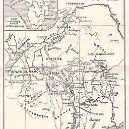
Itinéraire dans l'Afrique Occidentale (du Niger au Golfe de Guinée)
Permalink
https://digital.library.illinois.edu/items/20f9ffd0-e946-0133-1d3d-0050569601ca-d
This item is in the public domain.
Descriptive Information
| Title | Itinéraire dans l'Afrique Occidentale (du Niger au Golfe de Guinée) |
| Creator | Binger, Louis Gustave, 1856-1936 |
| Date | 1889 |
| Dimensions | 23.5 x 15.2 cm |
| Place of Publication | France |
| Cartographic Scale | 1:8,100,000 |
| Notes | Relief shown by hachures and spot heights. Includes 1 inset map: Carte d'Afrique indiquant la Région Explorée. Also in Bulletin de la Société de Géographie de Toulouse, V. 9 (Main Stacks, call No. 910.6SOCT). |
| Coverage-Spatial | Africa, West |
| Subject | |
| Genre | Maps |
| Language | French |
| Color | Bitonal |
| Technique | Lithography |
| Source | Bulletin de l'année, V. 11-12, back pocket. |
| Physical Location | stx |
| Map No. in Bassett and Scheven Bibliography | 2300 |
| Call Number | 910_6SOI |
| Map ID | afm0002300 |
| Rights | No Copyright - United States |
| Rights Description | This item is in the public domain. |
| Collection Title | Maps of Africa to 1900 |
| Repository | Rare Book & Manuscript Library |
| Type | Cartographic material |
| Collection | Maps of Africa to 1900 |
Download Options
|
Itinéraire dans l'Afrique Occidentale (du Niger au Golfe de Guinée) |
Contact us
for questions and to provide feedback.