


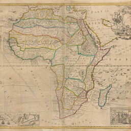
Map of Africa
Permalink
https://digital.library.illinois.edu/items/211a1770-e946-0133-1d3d-0050569601ca-c
This item is in the public domain.
Descriptive Information
| Title | Map of Africa |
| Creator | Grierson, George |
| Date | 1764 |
| Dimensions | 56.2 x 94.5 cm |
| Place of Publication | England |
| Cartographic Scale | 1:16,800,000 |
| Coverage-Spatial | Africa |
| Genre | Maps |
| Language | English |
| Source | The World Described, plate 6. |
| Physical Location | rbx |
| Map No. in Bassett and Scheven Bibliography | 95 |
| Call Number | XF_912M73W1764 |
| Map ID | afm0000095 |
| Rights | No Copyright - United States |
| Rights Description | This item is in the public domain. |
| Collection Title | Maps of Africa to 1900 |
| Repository | Rare Book & Manuscript Library |
| Type | Cartographic material |
| Collection | Maps of Africa to 1900 |
Download Options
|
Map of Africa |
Contact us
for questions and to provide feedback.