
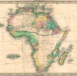
Africa
Permalink
https://digital.library.illinois.edu/items/215a4270-e946-0133-1d3d-0050569601ca-f
This item is in the public domain.
Descriptive Information
| Title | Africa |
| Creator | Tanner, Henry Schenck, 1786-1858 |
| Date | 1820-1829 |
| Dimensions | 49 x 54 cm |
| Cartographic Scale | 1:19,750,000 |
| Notes | Relief shown pictorially. |
| Coverage-Spatial | Africa |
| Subject | |
| Genre | Maps |
| Language | English |
| Color | Hand colored |
| Source | Loose sheet |
| Physical Location | max |
| Map No. in Bassett and Scheven Bibliography | 155 |
| Call Number | G8300182-_T3 |
| Map ID | afm0000155 |
| Rights | No Copyright - United States |
| Rights Description | This item is in the public domain. |
| Collection Title | Maps of Africa to 1900 |
| Repository | Rare Book & Manuscript Library |
| Type | Cartographic material |
| Collection | Maps of Africa to 1900 |
Download Options
Contact us
for questions and to provide feedback.