
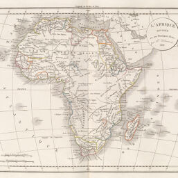
L'Afrique divise en ses principaux tats
Permalink
https://digital.library.illinois.edu/items/218443b0-e946-0133-1d3d-0050569601ca-3
This item is in the public domain.
Descriptive Information
| Title | L'Afrique divise en ses principaux tats |
| Creator | Delamarche, Charles François, 1740-1817 |
| Date | 1832 |
| Dimensions | 27.7 x 34.2 cm |
| Place of Publication | France |
| Cartographic Scale | 1:35,000,000 |
| Notes | Incorrect call No. given, the correct call No. is Q.912C15A1833. |
| Coverage-Spatial | Africa |
| Genre | Maps |
| Language | French |
| Color | Hand colored |
| Source | Atlas de la gographie, plate 18. |
| Physical Location | maos |
| Map No. in Bassett and Scheven Bibliography | 178 |
| Call Number | Q_912C15A1833 |
| Map ID | afm0000178 |
| Rights | No Copyright - United States |
| Rights Description | This item is in the public domain. |
| Collection Title | Maps of Africa to 1900 |
| Repository | Rare Book & Manuscript Library |
| Type | Cartographic material |
| Collection | Maps of Africa to 1900 |
Download Options
|
L'Afrique divise en ses principaux tats |
Contact us
for questions and to provide feedback.