
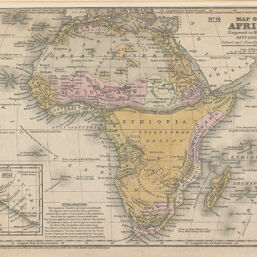
Map of Africa
Permalink
https://digital.library.illinois.edu/items/219ccad0-e946-0133-1d3d-0050569601ca-8
This item is in the public domain.
Descriptive Information
| Title | Map of Africa |
| Creator | Mitchell, S. Augustus (Samuel Augustus), 1792-1868 |
| Date | 1839 |
| Dimensions | 20.3 x 26.5 cm |
| Place of Publication | United States |
| Cartographic Scale | 1:43,000,000 |
| Coverage-Spatial | Africa |
| Genre | Maps |
| Language | English |
| Color | Hand colored |
| Technique | Lithography |
| Source | Mitchell's School Atlas, plate 37. |
| Physical Location | mar |
| Map No. in Bassett and Scheven Bibliography | 192 |
| Call Number | Q_912M69S1839 |
| Map ID | afm0000192 |
| Rights | No Copyright - United States |
| Rights Description | This item is in the public domain. |
| Collection Title | Maps of Africa to 1900 |
| Repository | Rare Book & Manuscript Library |
| Type | Cartographic material |
| Collection | Maps of Africa to 1900 |
Download Options
|
Map of Africa |
Contact us
for questions and to provide feedback.