
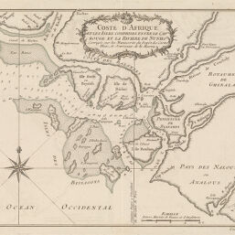
Coste d'Afrique et les Isles Comprises entre le Cap Rouge et la Riviere de Nunho
Permalink
https://digital.library.illinois.edu/items/21bba470-e946-0133-1d3d-0050569601ca-d
This item is in the public domain.
Descriptive Information
| Title | Coste d'Afrique et les Isles Comprises entre le Cap Rouge et la Riviere de Nunho |
| Creator | Bellin, Jacques Nicolas |
| Date | 1780-1789 |
| Dimensions | 20.4 x 25.9 cm |
| Cartographic Scale | 1:1,232,000 |
| Coverage-Spatial | Africa, West |
| Genre | Maps |
| Language | French |
| Source | Loose sheet |
| Physical Location | rbx |
| Map No. in Bassett and Scheven Bibliography | 2175 |
| Call Number | G8990178-_C6 |
| Map ID | afm0002175 |
| Rights | No Copyright - United States |
| Rights Description | This item is in the public domain. |
| Collection Title | Maps of Africa to 1900 |
| Repository | Rare Book & Manuscript Library |
| Type | Cartographic material |
| Collection | Maps of Africa to 1900 |
Download Options
|
Coste d'Afrique et les Isles Comprises entre le Cap Rouge et la Riviere de Nunho |
Contact us
for questions and to provide feedback.