
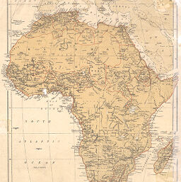
Africa
Permalink
https://digital.library.illinois.edu/items/21e6ff50-e946-0133-1d3d-0050569601ca-b
This item is in the public domain.
Descriptive Information
| Title | Africa |
| Date | 1875 |
| Dimensions | 32 x 22 cm |
| Cartographic Scale | 1:33,200,000 |
| Notes | Relief shown by hachures. |
| Coverage-Spatial | Africa |
| Subject | |
| Genre | Maps |
| Language | English |
| Color | Printed color |
| Technique | Lithography |
| Source | Loose sheet |
| Physical Location | max |
| Map No. in Bassett and Scheven Bibliography | 272 |
| Call Number | G82001875 |
| Map ID | afm0000272 |
| Rights | No Copyright - United States |
| Rights Description | This item is in the public domain. |
| Collection Title | Maps of Africa to 1900 |
| Repository | Rare Book & Manuscript Library |
| Type | Cartographic material |
| Collection | Maps of Africa to 1900 |
Download Options
Contact us
for questions and to provide feedback.