


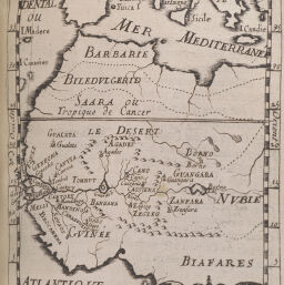
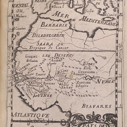
Pays des Negres
Permalink
https://digital.library.illinois.edu/items/21f53b40-e946-0133-1d3d-0050569601ca-1
This item is in the public domain.
Descriptive Information
| Title | Pays des Negres |
| Creator | Manesson-Mallet, Allain, 1630?-1706? |
| Date | 1685 |
| Dimensions | 14.4 x 10.1 cm |
| Place of Publication | France |
| Cartographic Scale | 1:50,000,000 |
| Coverage-Spatial | Africa, West |
| Genre | Maps |
| Language | French |
| Source | Description de l'univers, contenant les differents systemes di monde, les cartes generales & particulieres de la geographie ancienne & moderne: les plans & les profils des principales villes & des autres lieux plus considerables de la terre, V. 3, figs. 60-61. |
| Physical Location | rbx |
| Map No. in Bassett and Scheven Bibliography | 2133 |
| Call Number | X910M289D |
| Map ID | afm0002133 |
| Rights | No Copyright - United States |
| Rights Description | This item is in the public domain. |
| Collection Title | Maps of Africa to 1900 |
| Repository | Rare Book & Manuscript Library |
| Type | Cartographic material |
| Collection | Maps of Africa to 1900 |
Download Options
|
Pays des Negres: Figure LX | |
|
Pays des Negres: Figure LXI |
Contact us
for questions and to provide feedback.