
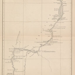
Traverse Survey of the White Nile from Khartum to Rigaf
Permalink
https://digital.library.illinois.edu/items/21fa9d20-e946-0133-1d3d-0050569601ca-e
This item is in the public domain.
Descriptive Information
| Title | Traverse Survey of the White Nile from Khartum to Rigaf |
| Creator | Chippendall, R. E. |
| Date | 1876 |
| Dimensions | 57.1 x 18 cm |
| Place of Publication | England |
| Cartographic Scale | 1:2,275,000 |
| Coverage-Spatial | Africa |
| Genre | Maps |
| Language | English |
| Source | Journal of the Royal Geographic Society, V. 46, between pp. 412-413. |
| Physical Location | rbx |
| Map No. in Bassett and Scheven Bibliography | 285 |
| Call Number | 910_6ROJ |
| Map ID | afm0000285 |
| Rights | No Copyright - United States |
| Rights Description | This item is in the public domain. |
| Collection Title | Maps of Africa to 1900 |
| Repository | Rare Book & Manuscript Library |
| Type | Cartographic material |
| Collection | Maps of Africa to 1900 |
Download Options
|
Traverse Survey of the White Nile from Khartum to Rigaf |
Contact us
for questions and to provide feedback.