
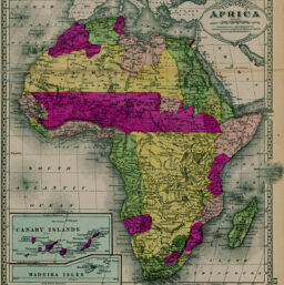
Tunison's Africa
Permalink
https://digital.library.illinois.edu/items/22438130-e946-0133-1d3d-0050569601ca-f
This item is in the public domain.
Descriptive Information
| Title | Tunison's Africa |
| Creator | Tunison, Henry Cuthbert, 1855- |
| Date | 1885 |
| Dimensions | 33 x 31 cm |
| Place of Publication | United States |
| Cartographic Scale | 1:26,500,000 |
| Notes | Relief shown pictorially. Includes 2 inset maps: Canary Islands and Madeira Isles. |
| Coverage-Spatial | Africa |
| Subject | |
| Genre | Maps |
| Language | English |
| Color | Hand colored |
| Technique | Lithography |
| Source | Peerless Universal Atlas, p. 139. |
| Physical Location | stx |
| Map No. in Bassett and Scheven Bibliography | 342 |
| Call Number | Q_912T83P |
| Map ID | afm0000342 |
| Rights | No Copyright - United States |
| Rights Description | This item is in the public domain. |
| Collection Title | Maps of Africa to 1900 |
| Repository | Rare Book & Manuscript Library |
| Type | Cartographic material |
| Collection | Maps of Africa to 1900 |
Download Options
|
Tunison's Africa |
Contact us
for questions and to provide feedback.