
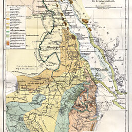
Phyto-Geographische Karte des Nilgebietes und der Uferländer des Rothen Meeres…von G. Schweinfurth, 1867
Permalink
https://digital.library.illinois.edu/items/225218a0-e946-0133-1d3d-0050569601ca-1
This item is in the public domain.
Descriptive Information
| Title | Phyto-Geographische Karte des Nilgebietes und der Uferländer des Rothen Meeres…von G. Schweinfurth, 1867 |
| Creator | Schweinfurth, G. |
| Date | 1886 |
| Dimensions | 33 x 22.5 cm |
| Cartographic Scale | 1:10,000,000 |
| Notes | Relief shown by hachures. Includes 1 inset map: Vergleichende Übersicht der benachbarten Florengebiete. |
| Coverage-Spatial | Nile River Watershed |
| Subject | |
| Genre | Maps |
| Language | German |
| Color | Printed color |
| Technique | Lithography |
| Source | Petermanns Geographische Mitteilungen, V. 14, plate 9. |
| Physical Location | stx |
| Map No. in Bassett and Scheven Bibliography | 351 |
| Call Number | Q_910_5PE |
| Map ID | afm0000351 |
| Rights | No Copyright - United States |
| Rights Description | This item is in the public domain. |
| Collection Title | Maps of Africa to 1900 |
| Repository | Rare Book & Manuscript Library |
| Type | Cartographic material |
| Collection | Maps of Africa to 1900 |
Download Options
|
Phyto-Geographische Karte des Nilgebietes und der Uferländer des Rothen Meeres…von G. Schweinfurth, 1867 |
Contact us
for questions and to provide feedback.