
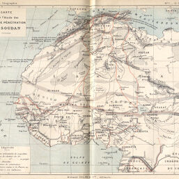
Carte pour l'étude des voies de pénétration au Soudan
Permalink
https://digital.library.illinois.edu/items/22949f60-e946-0133-1d3d-0050569601ca-7
This item is in the public domain.
Descriptive Information
| Title | Carte pour l'étude des voies de pénétration au Soudan |
| Creator | Benoit, François |
| Date | 1891 |
| Dimensions | 21 x 26.6 cm |
| Place of Publication | France |
| Cartographic Scale | 1:21,500,000 |
| Notes | Relief shown by hachures. |
| Coverage-Spatial | Africa |
| Subject | |
| Genre | Maps |
| Language | French |
| Color | Printed color |
| Technique | Lithography |
| Source | Annales de géographie : bulletin de la Société de géographie, V. 1, between pp. 120-121. |
| Physical Location | stx |
| Map No. in Bassett and Scheven Bibliography | 394 |
| Call Number | 910_5AN |
| Map ID | afm0000394 |
| Rights | No Copyright - United States |
| Rights Description | This item is in the public domain. |
| Collection Title | Maps of Africa to 1900 |
| Repository | Rare Book & Manuscript Library |
| Type | Cartographic material |
| Collection | Maps of Africa to 1900 |
Download Options
|
Carte pour l'étude des voies de pénétration au Soudan |
Contact us
for questions and to provide feedback.