
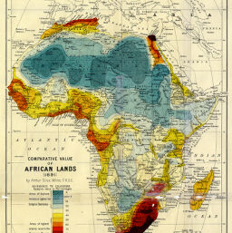
Comparative Value of African Lands
Permalink
https://digital.library.illinois.edu/items/229cfe90-e946-0133-1d3d-0050569601ca-f
This item is in the public domain.
Descriptive Information
| Title | Comparative Value of African Lands |
| Creator | White, A. Silva (Arthur Silva) 1859-1932 |
| Date | 1891 |
| Dimensions | 27.1 x 23.4 cm |
| Place of Publication | England |
| Cartographic Scale | 1:34,500,000 |
| Notes | Chloropleth map indicating areas of greatest resistance and economic value to Europeans. |
| Coverage-Spatial | Africa |
| Subject | |
| Genre | Maps |
| Language | English |
| Color | Printed color |
| Technique | Lithography |
| Source | Scottish geographical magazine, V. 7, between pp. 194-195. |
| Physical Location | stx |
| Map No. in Bassett and Scheven Bibliography | 400 |
| Call Number | 910_5SC |
| Map ID | afm0000400 |
| Rights | No Copyright - United States |
| Rights Description | This item is in the public domain. |
| Collection Title | Maps of Africa to 1900 |
| Repository | Rare Book & Manuscript Library |
| Type | Cartographic material |
| Collection | Maps of Africa to 1900 |
Download Options
|
Comparative Value of African Lands |
Contact us
for questions and to provide feedback.