
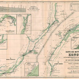
Karte des Mittleren Kongo
Permalink
https://digital.library.illinois.edu/items/22c5fb00-e946-0133-1d3d-0050569601ca-a
This item is in the public domain.
Descriptive Information
| Title | Karte des Mittleren Kongo |
| Creator | Baumann, Oskar, 1864-1899 |
| Date | 1889 |
| Extent | 1 map in 2 sections |
| Dimensions | 47.9 x 61.5 cm |
| Cartographic Scale | 1:400,000 |
| Notes | With elevation profile and 5 insets: Aequator-Station -- Uranga -- Stromenge bei Ngombe -- Bunga -- Bangala-Station. |
| Coverage-Spatial | Congo River |
| Subject | |
| Genre | Maps |
| Language | German |
| Color | Printed color |
| Source | Mitteilungen der Österreichischen Geographischen Gesellschaft, V. 32, between pp. 384-385. |
| Physical Location | stx |
| Map No. in Bassett and Scheven Bibliography | 2009 |
| Call Number | 910_5GEOW |
| Map ID | afm0002009 |
| Rights | No Copyright - United States |
| Rights Description | This item is in the public domain. |
| Collection Title | Maps of Africa to 1900 |
| Repository | Rare Book & Manuscript Library |
| Type | Cartographic material |
| Collection | Maps of Africa to 1900 |
Download Options
|
Karte des Mittleren Kongo |
Contact us
for questions and to provide feedback.