
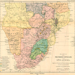
Karte der Politischen Einteilung von Süd-Afrika…
Permalink
https://digital.library.illinois.edu/items/22da5330-e946-0133-1d3d-0050569601ca-6
This item is in the public domain.
Descriptive Information
| Title | Karte der Politischen Einteilung von Süd-Afrika… |
| Creator | Hassenstein, Bruno |
| Date | 1896 |
| Dimensions | 32.2 x 35 cm |
| Cartographic Scale | 1:10,000,000 |
| Coverage-Spatial | Africa, Sub-Saharan |
| Subject | |
| Genre | Maps |
| Language | German |
| Color | Printed color |
| Technique | Lithography |
| Source | Petermanns geographische Mitteilungen, V. 42, plate 7. |
| Physical Location | stx |
| Map No. in Bassett and Scheven Bibliography | 437 |
| Call Number | Q_910_5PE |
| Map ID | afm0000437 |
| Rights | No Copyright - United States |
| Rights Description | This item is in the public domain. |
| Collection Title | Maps of Africa to 1900 |
| Repository | Rare Book & Manuscript Library |
| Type | Cartographic material |
| Collection | Maps of Africa to 1900 |
Download Options
|
Karte der Politischen Einteilung von Süd-Afrika… |
Contact us
for questions and to provide feedback.