
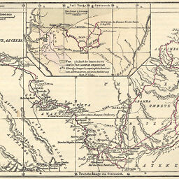
P. Savorgnan de Brazza's Reise auf dem oberen Ogowe und zu den westlichen Zuflüssen des Congo, 1876 bis 1878
Permalink
https://digital.library.illinois.edu/items/23801fc0-e946-0133-1d3d-0050569601ca-0
This item is in the public domain.
Descriptive Information
| Title | P. Savorgnan de Brazza's Reise auf dem oberen Ogowe und zu den westlichen Zuflüssen des Congo, 1876 bis 1878 |
| Creator | Hassenstein, Bruno |
| Date | 1879 |
| Dimensions | 12.3 x 17.4 cm |
| Cartographic Scale | 1:3,000,000 |
| Notes | Relief shown by hachures. Includes 1 inset map (scale 1:13,000,000) showing tribes along Brazza's route through Central Africa. |
| Coverage-Spatial | Ogooué River (Gabon) |
| Subject | |
| Genre | Maps |
| Language | German |
| Color | Hand colored |
| Technique | Lithography |
| Source | Petermanns geographische Mitteilungen, V. 25, p. 104. |
| Physical Location | stx |
| Map No. in Bassett and Scheven Bibliography | 1908 |
| Call Number | Q_910_5PE |
| Map ID | afm0001908 |
| Rights | No Copyright - United States |
| Rights Description | This item is in the public domain. |
| Collection Title | Maps of Africa to 1900 |
| Repository | Rare Book & Manuscript Library |
| Type | Cartographic material |
| Collection | Maps of Africa to 1900 |
Download Options
|
P. Savorgnan de Brazza's Reise auf dem oberen Ogowe und zu den westlichen Zuflüssen des Congo, 1876 bis 1878 |
Contact us
for questions and to provide feedback.