


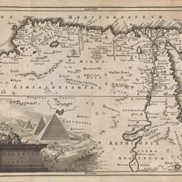
Aegyptus et Cyrenaica
Permalink
https://digital.library.illinois.edu/items/23abc210-e946-0133-1d3d-0050569601ca-2
This item is in the public domain.
Descriptive Information
| Title | Aegyptus et Cyrenaica |
| Creator | Cellarius, Christoph, 1638-1707 |
| Date | 1706 |
| Dimensions | 20.5 x 31 cm |
| Place of Publication | England |
| Cartographic Scale | 1:12,750,000 |
| Coverage-Spatial | Africa, North |
| Genre | Maps |
| Source | Notitia orbis antiqui, V. 2, lib. 4 on p. 2. |
| Physical Location | rbos |
| Map No. in Bassett and Scheven Bibliography | 572 |
| Call Number | 910C33N2 |
| Map ID | afm0000572 |
| Rights | No Copyright - United States |
| Rights Description | This item is in the public domain. |
| Collection Title | Maps of Africa to 1900 |
| Repository | Rare Book & Manuscript Library |
| Type | Cartographic material |
| Collection | Maps of Africa to 1900 |
Download Options
|
Aegyptus et Cyrenaica |
Contact us
for questions and to provide feedback.