
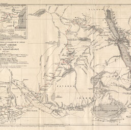
Carte provisoire pour l'intelligence du voyage du Lieutenant Cameron entre Ujiji et Cha Kalembi Afrique Equatoriale 1874-1875
Permalink
https://digital.library.illinois.edu/items/23bffc40-e946-0133-1d3d-0050569601ca-e
This item is in the public domain.
Descriptive Information
| Title | Carte provisoire pour l'intelligence du voyage du Lieutenant Cameron entre Ujiji et Cha Kalembi Afrique Equatoriale 1874-1875 |
| Date | 1876 |
| Dimensions | 21.7 x 29.3 cm |
| Cartographic Scale | 1:5,000,000 |
| Notes | Needs repair. |
| Coverage-Spatial | Africa, Central |
| Genre | Maps |
| Language | French |
| Color | Printed color |
| Technique | Lithography |
| Source | Bulletin de la Société de géographie, ser. 6, V. 11, after p. 15. |
| Physical Location | stx |
| Map No. in Bassett and Scheven Bibliography | 1878 |
| Call Number | 910_6SOGEASER_6 |
| Map ID | afm0001878 |
| Rights | No Copyright - United States |
| Rights Description | This item is in the public domain. |
| Collection Title | Maps of Africa to 1900 |
| Repository | Rare Book & Manuscript Library |
| Type | Cartographic material |
| Collection | Maps of Africa to 1900 |
Download Options
|
Carte provisoire pour l'intelligence du voyage du Lieutenant Cameron entre Ujiji et Cha Kalembi Afrique Equatoriale 1874-1875 |
Contact us
for questions and to provide feedback.