
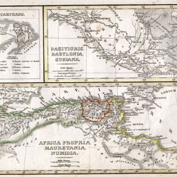
Africa Propria, Mauretania, Numidia
Permalink
https://digital.library.illinois.edu/items/24400b00-e946-0133-1d3d-0050569601ca-7
This item is in the public domain.
Descriptive Information
| Title | Africa Propria, Mauretania, Numidia |
| Creator | Stieler, Adolf, 1775-1836 |
| Date | 1837 |
| Dimensions | 9.6 x 22.8 cm |
| Place of Publication | Germany |
| Cartographic Scale | 1:11,200,000 |
| Notes | Relief shown by hachures. Includes two ancillary maps: Carthago -- Pasitigris, Babylonia, Susiana. |
| Coverage-Spatial | Babylon (Extinct city) |
| Subject | |
| Genre | Maps |
| Language | Latin |
| Color | Hand colored |
| Technique | Etched or engraved |
| Source | Schul-atlas, plate 58. |
| Physical Location | stx |
| Map No. in Bassett and Scheven Bibliography | 689 |
| Call Number | Q_912_3ST3S1837 |
| Map ID | afm0000689 |
| Rights | No Copyright - United States |
| Rights Description | This item is in the public domain. |
| Collection Title | Maps of Africa to 1900 |
| Repository | Rare Book & Manuscript Library |
| Type | Cartographic material |
| Collection | Maps of Africa to 1900 |
Download Options
|
Africa Propria, Mauretania, Numidia |
Contact us
for questions and to provide feedback.