
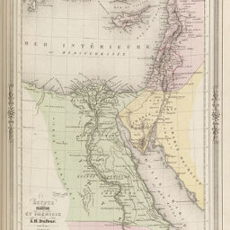
Egypte, Palestine et Phnicie
Permalink
https://digital.library.illinois.edu/items/24502b60-e946-0133-1d3d-0050569601ca-e
This item is in the public domain.
Descriptive Information
| Title | Egypte, Palestine et Phnicie |
| Creator | Dufour, A.-H. (Auguste-Henri), 1798-1865 |
| Date | 1852 |
| Dimensions | 31 x 23 cm |
| Place of Publication | France |
| Cartographic Scale | 1:5,800,000 |
| Coverage-Spatial | Africa, North |
| Genre | Maps |
| Language | French |
| Color | Hand colored |
| Source | Atlas illustr, plate 38. |
| Physical Location | maos |
| Map No. in Bassett and Scheven Bibliography | 701 |
| Call Number | Q_912B233A |
| Map ID | afm0000701 |
| Rights | No Copyright - United States |
| Rights Description | This item is in the public domain. |
| Collection Title | Maps of Africa to 1900 |
| Repository | Rare Book & Manuscript Library |
| Type | Cartographic material |
| Collection | Maps of Africa to 1900 |
Download Options
|
Egypte, Palestine et Phnicie |
Contact us
for questions and to provide feedback.