
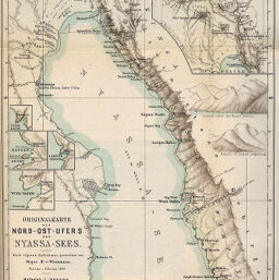
Originalkarte des Nord-Ost-Ufers des Nyassa-Sees…
Permalink
https://digital.library.illinois.edu/items/24548800-e946-0133-1d3d-0050569601ca-c
This item is in the public domain.
Descriptive Information
| Title | Originalkarte des Nord-Ost-Ufers des Nyassa-Sees… |
| Creator | Wissmann, Hermann von, 1853-1905 |
| Date | 1893 |
| Dimensions | 30.5 x 24.5 cm |
| Place of Publication | Germany |
| Cartographic Scale | 1:600,000 |
| Notes | Relief shown by landform drawings and spot heights. Includes 4 inset closeups of harbors and 1 inset (scale 1:1,200,000): Dr. Bumiller's route 30 Januar bis 23 Febr. 1893. |
| Coverage-Spatial | Nyasa, Lake |
| Subject | |
| Genre | Maps |
| Language | German |
| Color | Printed color |
| Technique | Lithography |
| Source | Petermanns geographische Mitteilungen, V. 39, plate 14. |
| Physical Location | stx |
| Map No. in Bassett and Scheven Bibliography | 1777 |
| Call Number | Q_910_5PE |
| Map ID | afm0001777 |
| Rights | No Copyright - United States |
| Rights Description | This item is in the public domain. |
| Collection Title | Maps of Africa to 1900 |
| Repository | Rare Book & Manuscript Library |
| Type | Cartographic material |
| Collection | Maps of Africa to 1900 |
Download Options
|
Originalkarte des Nord-Ost-Ufers des Nyassa-Sees… |
Contact us
for questions and to provide feedback.