
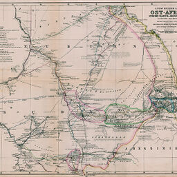
Entwurf Einer Karte von Ost-Afrika zwischen Chartúm & dem Rothen Meere bis Sauakin und Massaua
Permalink
https://digital.library.illinois.edu/items/24797d40-e946-0133-1d3d-0050569601ca-2
This item is in the public domain.
Descriptive Information
| Title | Entwurf Einer Karte von Ost-Afrika zwischen Chartúm & dem Rothen Meere bis Sauakin und Massaua |
| Creator | Petermann, A. (August), 1822-1878 |
| Date | 1861 |
| Dimensions | 43.5 x 52.6 cm |
| Place of Publication | Germany |
| Cartographic Scale | 1:1,500,000 |
| Notes | Relief shown by hachures and spot heights. Paris meridian. Explorers' routes indicated in color. |
| Coverage-Spatial | Sudan |
| Subject | |
| Genre | Maps |
| Language | German |
| Color | Hand colored |
| Technique | Lithography |
| Source | Petermanns geographische Mitteilungen, V. 1, between pp. 16-17. |
| Physical Location | stx |
| Map No. in Bassett and Scheven Bibliography | 726 |
| Call Number | Q_910_5PE |
| Map ID | afm0000726 |
| Rights | No Copyright - United States |
| Rights Description | This item is in the public domain. |
| Collection Title | Maps of Africa to 1900 |
| Repository | Rare Book & Manuscript Library |
| Type | Cartographic material |
| Collection | Maps of Africa to 1900 |
Download Options
|
Entwurf Einer Karte von Ost-Afrika zwischen Chartúm & dem Rothen Meere bis Sauakin und Massaua |
Contact us
for questions and to provide feedback.