
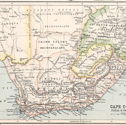
Cape Colony, Natal & Transvaal
Permalink
https://digital.library.illinois.edu/items/248de480-e946-0133-1d3d-0050569601ca-1
This item is in the public domain.
Descriptive Information
| Title | Cape Colony, Natal & Transvaal |
| Creator | Bartholomew, J. G. (John George), 1860-1920 |
| Date | 1890 |
| Dimensions | 15.5 x 23 cm |
| Place of Publication | England |
| Cartographic Scale | 1:8,960,000 |
| Notes | Relief shown by hachures. |
| Coverage-Spatial | Bechuanaland Protectorate |
| Subject | |
| Genre | Maps |
| Language | English |
| Color | Printed color |
| Technique | Lithography |
| Source | Century Atlas, plate 39. |
| Physical Location | stx |
| Map No. in Bassett and Scheven Bibliography | 1749 |
| Call Number | Q_912B28CE |
| Map ID | afm0001749 |
| Rights | No Copyright - United States |
| Rights Description | This item is in the public domain. |
| Collection Title | Maps of Africa to 1900 |
| Repository | Rare Book & Manuscript Library |
| Type | Cartographic material |
| Collection | Maps of Africa to 1900 |
Download Options
|
Cape Colony, Natal & Transvaal |
Contact us
for questions and to provide feedback.