
Egyptian Ascending under Rameses II
Permalink
https://digital.library.illinois.edu/items/24d8bdb0-e946-0133-1d3d-0050569601ca-3
This item is in the public domain.
Descriptive Information
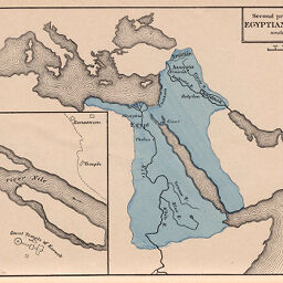
| Title | Egyptian Ascending under Rameses II |
| Creator | Labberton, Robert H. (Robert Henlopen), 1812-1898 |
| Date | 1874 |
| Dimensions | 14 x 21.4 cm |
| Place of Publication | United States |
| Cartographic Scale | 1:250,000,000 |
| Notes | Includes 1 inset map: Ruins of Thebes. |
| Coverage-Spatial | Thebes (Egypt : Extinct city) |
| Subject | |
| Genre | Maps |
| Language | English |
| Color | Hand colored |
| Technique | Lithography |
| Source | Historical Atlas, plate 2. |
| Physical Location | stx |
| Map No. in Bassett and Scheven Bibliography | 787 |
| Call Number | 911L11H1874 |
| Map ID | afm0000787 |
| Rights | No Copyright - United States |
| Rights Description | This item is in the public domain. |
| Collection Title | Maps of Africa to 1900 |
| Repository | Rare Book & Manuscript Library |
| Type | Cartographic material |
| Collection | Maps of Africa to 1900 |
Download Options
|
Egyptian Ascending under Rameses II |
Contact us
for questions and to provide feedback.