
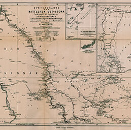
Specialkarte vom Mittleren Ost-Sudan...
Permalink
https://digital.library.illinois.edu/items/2505d570-e946-0133-1d3d-0050569601ca-8
This item is in the public domain.
Descriptive Information
| Title | Specialkarte vom Mittleren Ost-Sudan... |
| Creator | Zoeppritz, K. |
| Date | 1877 |
| Dimensions | 33.5 x 48.5 cm |
| Place of Publication | Germany |
| Cartographic Scale | 1:1,000,000 |
| Notes | Relief shown by hachures and spot heights. Includes inset maps: Der Wisse Nil -- Cebel Cule -- Die Nördlichen Gebâl-el-Fung -- Berggruppe Nôrd & Gemmân. |
| Coverage-Spatial | Nile River Watershed |
| Subject | |
| Genre | Maps |
| Language | German |
| Color | Hand colored |
| Technique | Lithography |
| Source | Petermanns geographische Mitteilungen, V. 11, No. 50, between pp. 38-39. |
| Physical Location | stx |
| Map No. in Bassett and Scheven Bibliography | 813 |
| Call Number | Q_910_5PE |
| Map ID | afm0000813 |
| Rights | No Copyright - United States |
| Rights Description | This item is in the public domain. |
| Collection Title | Maps of Africa to 1900 |
| Repository | Rare Book & Manuscript Library |
| Type | Cartographic material |
| Collection | Maps of Africa to 1900 |
Download Options
|
Specialkarte vom Mittleren Ost-Sudan... |
Contact us
for questions and to provide feedback.