
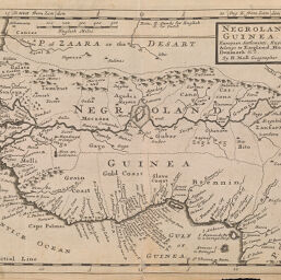
Negroland and Guinea, with the European settlements, explaining what belongs to England, Holland, Denmark &c.
Permalink
https://digital.library.illinois.edu/items/252e04a0-e946-0133-1d3d-0050569601ca-f
This item is in the public domain.
Descriptive Information
| Title | Negroland and Guinea, with the European settlements, explaining what belongs to England, Holland, Denmark &c. |
| Creator | Moll, Herman, -1732 |
| Date | 1732 |
| Dimensions | 20.5 x 27.5 cm |
| Place of Publication | Paris (France) |
| Cartographic Scale | 1:14,750,000 |
| Coverage-Spatial | Africa, West |
| Genre | Maps |
| Language | English |
| Source | Atlas minor: or a new and curious set of sixty-two maps… |
| Physical Location | Professor Thomas Bassett Personal Collection |
| Bibliography | Rumsey Collection No. 5580.042 |
| Map ID | afm0003207 |
| Rights | No Copyright - United States |
| Rights Description | This item is in the public domain. |
| Collection Title | Maps of Africa to 1900 |
| Repository | Rare Book & Manuscript Library |
| Type | Cartographic material |
| Collection | Maps of Africa to 1900 |
Download Options
|
Negroland and Guinea, with the European settlements, explaining what belongs to England, Holland, Denmark &c. |
Contact us
for questions and to provide feedback.