
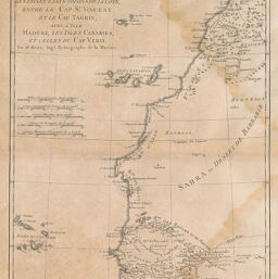
Partie Occidentale de Afrique contenant les Pays et Etats voisin de la Côte, entre le Cap St. Vincent et le Cap Tagrin avec Isle Madere, les Isles Canaries, et celles du Cap Verd
Permalink
https://digital.library.illinois.edu/items/25bf81a0-e946-0133-1d3d-0050569601ca-2
This item is in the public domain.
Descriptive Information
| Title | Partie Occidentale de Afrique contenant les Pays et Etats voisin de la Côte, entre le Cap St. Vincent et le Cap Tagrin avec Isle Madere, les Isles Canaries, et celles du Cap Verd |
| Creator | Bonne, Rigobert |
| Date | 1788 |
| Dimensions | 34.5 x 23.4 cm |
| Place of Publication | France |
| Cartographic Scale | 1:9,625,000 |
| Coverage-Spatial | Africa, West |
| Genre | Maps |
| Language | French |
| Source | Atlas encyclopédique, V. 2, plate 100. |
| Physical Location | rbx |
| Map No. in Bassett and Scheven Bibliography | 2182 |
| Call Number | XQ_912AT65 |
| Map ID | afm0002182 |
| Rights | No Copyright - United States |
| Rights Description | This item is in the public domain. |
| Collection Title | Maps of Africa to 1900 |
| Repository | Rare Book & Manuscript Library |
| Type | Cartographic material |
| Collection | Maps of Africa to 1900 |
Download Options
|
Partie Occidentale de Afrique contenant les Pays et Etats voisin de la Côte, entre le Cap St. Vincent et le Cap Tagrin avec Isle Madere, les Isles Canaries, et celles du Cap Verd |
Contact us
for questions and to provide feedback.