
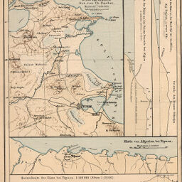
Das Deltaland des Medjerda und die Landschaft von tunis, Karthago, Utica und Biserta
Permalink
https://digital.library.illinois.edu/items/25ca11a0-e946-0133-1d3d-0050569601ca-2
This item is in the public domain.
Descriptive Information
| Title | Das Deltaland des Medjerda und die Landschaft von tunis, Karthago, Utica und Biserta |
| Creator | Fischer, Th. |
| Date | 1887 |
| Dimensions | 24.5 x 19.5 cm |
| Place of Publication | Germany |
| Cartographic Scale | 1:400,000 |
| Notes | Cleaned with brush or eraser. |
| Coverage-Spatial | Africa, North |
| Genre | Maps |
| Language | German |
| Color | Printed color |
| Technique | Lithography |
| Source | Petermanns geographische Mitteilungen, V. 33, plate 1. |
| Physical Location | stx |
| Map No. in Bassett and Scheven Bibliography | 893 |
| Call Number | Q_910_5PE |
| Map ID | afm0000893 |
| Rights | No Copyright - United States |
| Rights Description | This item is in the public domain. |
| Collection Title | Maps of Africa to 1900 |
| Repository | Rare Book & Manuscript Library |
| Type | Cartographic material |
| Collection | Maps of Africa to 1900 |
Download Options
|
Das Deltaland des Medjerda und die Landschaft von tunis, Karthago, Utica und Biserta |
Contact us
for questions and to provide feedback.