
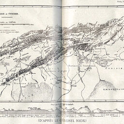
Algérie et Tunisie
Permalink
https://digital.library.illinois.edu/items/260c46b0-e946-0133-1d3d-0050569601ca-a
This item is in the public domain.
Descriptive Information
| Title | Algérie et Tunisie |
| Creator | Niox, G. (Gustave), 1840-1921 |
| Date | 1889 |
| Dimensions | 23.7 x 29 cm |
| Place of Publication | France |
| Cartographic Scale | 1:5,00,000 |
| Notes | Includes 3 elevation profiles in margins: Coupe par le méridien d'Oran -- Coupe par le 34e degré de latitude -- Coupe par le méridien de Constantine. Relief shown by landform drawings and spot heights. |
| Coverage-Spatial | Tunisia |
| Subject | |
| Genre | Maps |
| Language | French |
| Color | Printed color |
| Technique | Lithography |
| Source | Revue géographique internationale, V. 14, between pp. 172-173. |
| Physical Location | stos |
| Map No. in Bassett and Scheven Bibliography | 914 |
| Call Number | 910_5REGI |
| Map ID | afm0000914 |
| Rights | No Copyright - United States |
| Rights Description | This item is in the public domain. |
| Collection Title | Maps of Africa to 1900 |
| Repository | Rare Book & Manuscript Library |
| Type | Cartographic material |
| Collection | Maps of Africa to 1900 |
Download Options
|
Algérie et Tunisie |
Contact us
for questions and to provide feedback.