
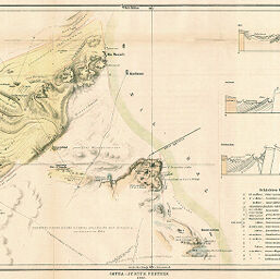
Geologisch Topographische Karte der Kreide-Region bei den Pyramiden
Permalink
https://digital.library.illinois.edu/items/26250d90-e946-0133-1d3d-0050569601ca-e
This item is in the public domain.
Descriptive Information
| Title | Geologisch Topographische Karte der Kreide-Region bei den Pyramiden |
| Creator | Schweinfurth, G. |
| Date | 1889 |
| Dimensions | 27.5 x 52.5 cm |
| Place of Publication | Germany |
| Cartographic Scale | 1:60,000 |
| Notes | Includes 3 inset geologic cross sections. |
| Coverage-Spatial | Jīzah (Egypt) |
| Subject | |
| Genre | Maps |
| Language | German |
| Color | Printed color |
| Technique | Lithography |
| Source | Petermanns geographische Mitteilungen, V. 35, plate 1. |
| Physical Location | stx |
| Map No. in Bassett and Scheven Bibliography | 921 |
| Call Number | Q_910_5PE |
| Map ID | afm0000921 |
| Rights | No Copyright - United States |
| Rights Description | This item is in the public domain. |
| Collection Title | Maps of Africa to 1900 |
| Repository | Rare Book & Manuscript Library |
| Type | Cartographic material |
| Collection | Maps of Africa to 1900 |
Download Options
|
Geologisch Topographische Karte der Kreide-Region bei den Pyramiden |
Contact us
for questions and to provide feedback.