
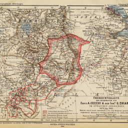
Übersichtskarte der Reiserouten des Capit. A. Cecchi & des Ingr. G. Chiarini im Südlichen Abessinien, 1876 bis 1881
Permalink
https://digital.library.illinois.edu/items/26c3eb30-e946-0133-1d3d-0050569601ca-4
This item is in the public domain.
Descriptive Information
| Title | Übersichtskarte der Reiserouten des Capit. A. Cecchi & des Ingr. G. Chiarini im Südlichen Abessinien, 1876 bis 1881 |
| Creator | Habenicht, Hermann, 1844-1917 |
| Date | 1886 |
| Dimensions | 19 x 24.5 cm |
| Place of Publication | Germany |
| Cartographic Scale | 1:4,000,000 |
| Notes | Relief shown by hachures and spot heights. Routes indicated by red lines. |
| Coverage-Spatial | Horn of Africa |
| Subject | |
| Genre | Maps |
| Language | German |
| Color | Printed color |
| Technique | Lithography |
| Source | Petermanns geographische Mitteilungen, V. 32, plate 15. |
| Physical Location | stx |
| Map No. in Bassett and Scheven Bibliography | 1288 |
| Call Number | Q_910_5PE |
| Map ID | afm0001288 |
| Rights | No Copyright - United States |
| Rights Description | This item is in the public domain. |
| Collection Title | Maps of Africa to 1900 |
| Repository | Rare Book & Manuscript Library |
| Type | Cartographic material |
| Collection | Maps of Africa to 1900 |
Download Options
|
Übersichtskarte der Reiserouten des Capit. A. Cecchi & des Ingr. G. Chiarini im Südlichen Abessinien, 1876 bis 1881 |
Contact us
for questions and to provide feedback.