


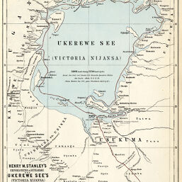
Henry M. Stanley's Erforschung & Aufnahme des Ukerewe See's (Victoria Noijansa)
Permalink
https://digital.library.illinois.edu/items/26df3e90-e946-0133-1d3d-0050569601ca-9
This item is in the public domain.
Descriptive Information
| Title | Henry M. Stanley's Erforschung & Aufnahme des Ukerewe See's (Victoria Noijansa) |
| Creator | Koffmahn, O. (Otto), 1851-1916 |
| Date | 1875 |
| Dimensions | 24.8 x 19 cm |
| Place of Publication | Germany |
| Cartographic Scale | 1:2,500,000 |
| Notes | Relief shown by hachures. Stanley's route indicated in red (map also shows Speke's 1858 and 1861/62 expeditions). |
| Coverage-Spatial | Victoria, Lake |
| Subject | |
| Genre | Maps |
| Language | German |
| Color | Hand colored |
| Technique | Lithography |
| Source | Petermanns geographische Mitteilungen, V. 21, plate 23. |
| Physical Location | stx |
| Map No. in Bassett and Scheven Bibliography | 1164 |
| Call Number | Q_910_5PE |
| Map ID | afm0001164 |
| Rights | No Copyright - United States |
| Rights Description | This item is in the public domain. |
| Collection Title | Maps of Africa to 1900 |
| Repository | Rare Book & Manuscript Library |
| Type | Cartographic material |
| Collection | Maps of Africa to 1900 |
Download Options
|
Henry M. Stanley's Erforschung & Aufnahme des Ukerewe See's (Victoria Noijansa) |
Contact us
for questions and to provide feedback.