
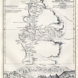
Specialkarte des Hochlandes von Abessinien zwischen Tekonda und Addigerat
Permalink
https://digital.library.illinois.edu/items/27004410-e946-0133-1d3d-0050569601ca-f
This item is in the public domain.
Descriptive Information
| Title | Specialkarte des Hochlandes von Abessinien zwischen Tekonda und Addigerat |
| Creator | Petermann, A. (August), 1822-1878 |
| Date | 1868 |
| Dimensions | 24.2 x 19.2 cm |
| Place of Publication | Germany |
| Cartographic Scale | 1:300,000 |
| Notes | Relief shown by hachures. Includes 1 inset view: Magdala und Umgebung. |
| Coverage-Spatial | Ethiopia |
| Subject | |
| Genre | Maps |
| Language | German |
| Color | Bitonal |
| Technique | Lithography |
| Source | Petermanns geographische Mitteilungen, V. 14, plate 11. |
| Physical Location | stx |
| Map No. in Bassett and Scheven Bibliography | 1136 |
| Call Number | Q_910_5PE |
| Map ID | afm0001136 |
| Rights | No Copyright - United States |
| Rights Description | This item is in the public domain. |
| Collection Title | Maps of Africa to 1900 |
| Repository | Rare Book & Manuscript Library |
| Type | Cartographic material |
| Collection | Maps of Africa to 1900 |
Download Options
|
Specialkarte des Hochlandes von Abessinien zwischen Tekonda und Addigerat |
Contact us
for questions and to provide feedback.