
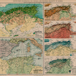
Drawings and graphics illustrating the Physical and Political Geography of Algeria
Permalink
https://digital.library.illinois.edu/items/27314190-e946-0133-1d3d-0050569601ca-8
This item is in the public domain.
Descriptive Information
| Title | Drawings and graphics illustrating the Physical and Political Geography of Algeria |
| Creator | Bartholomew, J. G. (John George), 1860-1920 |
| Date | 1894 |
| Dimensions | 32.9 x 35.6 cm |
| Place of Publication | England |
| Cartographic Scale |
|
| Notes | Six maps on 1 sheet: Plants and Surface Features -- Political and Commerical Outlines -- Orographical Features -- Mean Annual Tempertaure -- Mean Annual Rainfall -- Progress of French Conquest. |
| Coverage-Spatial | Algeria |
| Subject | |
| Genre | Maps |
| Language | English |
| Color | Printed color |
| Technique | Lithography |
| Source | Scottish geographical magazine, V. 10, between pp. 194-195. |
| Physical Location | stx |
| Map No. in Bassett and Scheven Bibliography | 974 |
| Call Number | 910_5SC |
| Map ID | afm0000974 |
| Rights | No Copyright - United States |
| Rights Description | This item is in the public domain. |
| Collection Title | Maps of Africa to 1900 |
| Repository | Rare Book & Manuscript Library |
| Type | Cartographic material |
| Collection | Maps of Africa to 1900 |
Download Options
|
Drawings and graphics illustrating the Physical and Political Geography of Algeria |
Contact us
for questions and to provide feedback.