
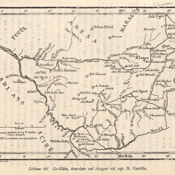
Schizzo del Co-Hàin, tracciato sul disegno del Cap. N. Gentile
Permalink
https://digital.library.illinois.edu/items/275cb830-e946-0133-1d3d-0050569601ca-f
This item is in the public domain.
Descriptive Information
| Title | Schizzo del Co-Hàin, tracciato sul disegno del Cap. N. Gentile |
| Creator | Dardano, A. (Achille), 1870-1938 |
| Date | 1894 |
| Dimensions | 10.5 x 14.3 cm |
| Place of Publication | Italy |
| Cartographic Scale | 1:5,000 |
| Coverage-Spatial | Africa, Eastern |
| Genre | Maps |
| Language | Italian |
| Color | Bitonal |
| Technique | Lithography and aquatint |
| Source | Bollettino della Societa geografica italiana, ser. 3, V. 7, p. 163. |
| Physical Location | stx |
| Map No. in Bassett and Scheven Bibliography | 1458 |
| Call Number | 910_6SORSER_3 |
| Map ID | afm0001458 |
| Rights | No Copyright - United States |
| Rights Description | This item is in the public domain. |
| Collection Title | Maps of Africa to 1900 |
| Repository | Rare Book & Manuscript Library |
| Type | Cartographic material |
| Collection | Maps of Africa to 1900 |
Download Options
|
Schizzo del Co-Hàin, tracciato sul disegno del Cap. N. Gentile |
Contact us
for questions and to provide feedback.