
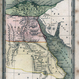
Egypt
Permalink
https://digital.library.illinois.edu/items/278de1f0-e946-0133-1d3d-0050569601ca-a
This item is in the public domain.
Descriptive Information
| Title | Egypt |
| Creator | Starling, Thomas |
| Date | 1830 |
| Dimensions | 14.5 x 9 cm |
| Place of Publication | England |
| Cartographic Scale | 1:9,400,000 |
| Coverage-Spatial | Africa, North |
| Genre | Maps |
| Language | English |
| Source | Geographical Annual, p. 74. |
| Physical Location | rbx |
| Map No. in Bassett and Scheven Bibliography | 675 |
| Call Number | 912ST28G1833 |
| Map ID | afm0000675 |
| Rights | No Copyright - United States |
| Rights Description | This item is in the public domain. |
| Collection Title | Maps of Africa to 1900 |
| Repository | Rare Book & Manuscript Library |
| Type | Cartographic material |
| Collection | Maps of Africa to 1900 |
Download Options
Contact us
for questions and to provide feedback.