
Carte Hydrographique de l'Afrique
Permalink
https://digital.library.illinois.edu/items/27994d60-e946-0133-1d3d-0050569601ca-b
This item is in the public domain.
Descriptive Information
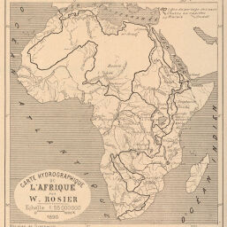
| Title | Carte Hydrographique de l'Afrique |
| Creator | Rosier, W. (William), 1856-1924 |
| Date | 1890 |
| Dimensions | 15.7 x 14.8 cm |
| Place of Publication | Switzerland |
| Cartographic Scale | 1:55,000,000 |
| Coverage-Spatial | Africa |
| Genre | Maps |
| Language | French |
| Color | Bitonal |
| Technique | Lithography |
| Source | Le Globe : bulletin et mémoires de la Société de géographie de Genève, V. 29, after p. 60. |
| Physical Location | stx |
| Map No. in Bassett and Scheven Bibliography | 389 |
| Call Number | 910_5GLO |
| Map ID | afm0000389 |
| Rights | No Copyright - United States |
| Rights Description | This item is in the public domain. |
| Collection Title | Maps of Africa to 1900 |
| Repository | Rare Book & Manuscript Library |
| Type | Cartographic material |
| Collection | Maps of Africa to 1900 |
Download Options
|
Carte Hydrographique de l'Afrique |
Contact us
for questions and to provide feedback.