
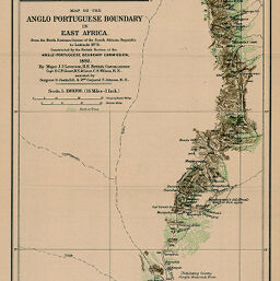
Map of the Anglo Portuguese Boundary in East Africa
Permalink
https://digital.library.illinois.edu/items/28115fd0-e946-0133-1d3d-0050569601ca-5
This item is in the public domain.
Descriptive Information
| Title | Map of the Anglo Portuguese Boundary in East Africa |
| Creator | Wilson, C. S. |
| Date | 1892 |
| Dimensions | 51.9 x 20.8 cm |
| Place of Publication | England |
| Cartographic Scale | 1:1,000,000 |
| Notes | Relief shown by shading, hachures, and spot heights. Includes 1 inset map: Massikesii and Surrounding Country. |
| Coverage-Spatial | Portuguese East Africa |
| Subject | |
| Genre | Maps |
| Language | English |
| Color | Printed color |
| Source | The Geographical Journal, V. 2, between pp. 376-377. |
| Physical Location | stx |
| Map No. in Bassett and Scheven Bibliography | 1403 |
| Call Number | 910_5GJ |
| Map ID | afm0001403 |
| Rights | No Copyright - United States |
| Rights Description | This item is in the public domain. |
| Collection Title | Maps of Africa to 1900 |
| Repository | Rare Book & Manuscript Library |
| Type | Cartographic material |
| Collection | Maps of Africa to 1900 |
Download Options
|
Map of the Anglo Portuguese Boundary in East Africa |
Contact us
for questions and to provide feedback.