
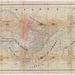
Campagne 1889-1990: Lieutenant Colonel Archinard Ct Supérieure, Carte Politique du Soudan Français, Echelle 1/1.500.000
Permalink
https://digital.library.illinois.edu/items/2858e080-e946-0133-1d3d-0050569601ca-d
This item is in the public domain.
Descriptive Information
| Title | Campagne 1889-1990: Lieutenant Colonel Archinard Ct Supérieure, Carte Politique du Soudan Français, Echelle 1/1.500.000 |
| Date | 1889-1890 |
| Dimensions | 71 x 212.5 cm |
| Cartographic Scale | 1:1,500,000 |
| Notes | A manuscript map showing the political geography of European and African territories in 1890. |
| Coverage-Spatial | Africa, West |
| Genre | Maps |
| Language | French |
| Physical Location | Professor Thomas Bassett Personal Collection |
| Map ID | afm0003235 |
| Rights | No Copyright - United States |
| Rights Description | This item is in the public domain. |
| Collection Title | Maps of Africa to 1900 |
| Repository | Rare Book & Manuscript Library |
| Type | Cartographic material |
| Collection | Maps of Africa to 1900 |
Download Options
|
Campagne 1889-1990: Lieutenant Colonel Archinard Ct Supérieure, Carte Politique du Soudan Français, Echelle 1/1.500.000 |
Contact us
for questions and to provide feedback.