
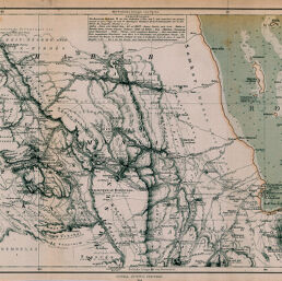
Orginalkarte der Nord-Abessinischen Grenzlande: Bogos, Mensa, Marea, und der umliegenden Gebiete
Permalink
https://digital.library.illinois.edu/items/28e02410-e946-0133-1d3d-0050569601ca-0
This item is in the public domain.
Descriptive Information
| Title | Orginalkarte der Nord-Abessinischen Grenzlande: Bogos, Mensa, Marea, und der umliegenden Gebiete |
| Creator | Hassenstein, Bruno |
| Date | 1864 |
| Dimensions | 24.9 x 50.7 cm |
| Place of Publication | Germany |
| Cartographic Scale | 1:500,000 |
| Notes | Relief shown by hachures, depths shown by soundings and bathymetric tints. |
| Coverage-Spatial | Dahlak Archipelago (Eritrea) |
| Subject | |
| Genre | Maps |
| Language | German |
| Color | Hand colored |
| Technique | Lithography |
| Source | Petermanns geographische Mitteilungen, V.3, No. 13, after p. 46. |
| Physical Location | stx |
| Map No. in Bassett and Scheven Bibliography | 1116 |
| Call Number | Q_910_5PE |
| Map ID | afm0001116 |
| Rights | No Copyright - United States |
| Rights Description | This item is in the public domain. |
| Collection Title | Maps of Africa to 1900 |
| Repository | Rare Book & Manuscript Library |
| Type | Cartographic material |
| Collection | Maps of Africa to 1900 |
Download Options
|
Orginalkarte der Nord-Abessinischen Grenzlande: Bogos, Mensa, Marea, und der umliegenden Gebiete |
Contact us
for questions and to provide feedback.