
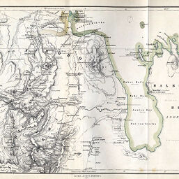
Die nördlichen Zugänge zu Abessinien, Specialkarte des Nordabessinn. Gebirgslandes zwischen Massaua und Halay
Permalink
https://digital.library.illinois.edu/items/290adf00-e946-0133-1d3d-0050569601ca-6
This item is in the public domain.
Descriptive Information
| Title | Die nördlichen Zugänge zu Abessinien, Specialkarte des Nordabessinn. Gebirgslandes zwischen Massaua und Halay |
| Creator | Habenicht, Hermann, 1844-1917 |
| Date | 1867 |
| Dimensions | 24.3 x 43.2 cm |
| Place of Publication | Germany |
| Cartographic Scale | 1:300,000 |
| Notes | Relief shown by hachures, contours and spot heights. |
| Coverage-Spatial | Abyssinia |
| Subject | |
| Genre | Maps |
| Language | German |
| Color | Hand colored |
| Technique | Lithography |
| Source | Petermanns geographische Mitteilungen, V. 13, plate 14. |
| Physical Location | stx |
| Map No. in Bassett and Scheven Bibliography | 1128 |
| Call Number | Q_910_5PE |
| Map ID | afm0001128 |
| Rights | No Copyright - United States |
| Rights Description | This item is in the public domain. |
| Collection Title | Maps of Africa to 1900 |
| Repository | Rare Book & Manuscript Library |
| Type | Cartographic material |
| Collection | Maps of Africa to 1900 |
Download Options
|
Die nördlichen Zugänge zu Abessinien, Specialkarte des Nordabessinn. Gebirgslandes zwischen Massaua und Halay |
Contact us
for questions and to provide feedback.