
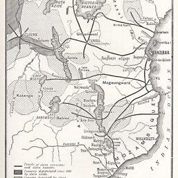
Map to illustrate Mr. Stevenson's address on “The Arabs in Africa” and the Nyassa Conference
Permalink
https://digital.library.illinois.edu/items/2917fa50-e946-0133-1d3d-0050569601ca-f
This item is in the public domain.
Descriptive Information
| Title | Map to illustrate Mr. Stevenson's address on “The Arabs in Africa” and the Nyassa Conference |
| Creator | Stevenson, James |
| Date | 1888 |
| Dimensions | 12.9 x 10.1 cm |
| Place of Publication | England |
| Cartographic Scale | 1:18,000,000 |
| Notes | Shows tracks of slave caravans and areas depopulated by the slave trade. |
| Coverage-Spatial | Zambia |
| Subject | |
| Genre | Maps |
| Language | English |
| Color | Bitonal |
| Technique | Lithography |
| Source | The Journal of the Manchester Geographical Society, V. 4, between pp. 72-73. |
| Physical Location | stx |
| Map No. in Bassett and Scheven Bibliography | 1326 |
| Call Number | 910_6MA |
| Map ID | afm0001326 |
| Rights | No Copyright - United States |
| Rights Description | This item is in the public domain. |
| Collection Title | Maps of Africa to 1900 |
| Repository | Rare Book & Manuscript Library |
| Type | Cartographic material |
| Collection | Maps of Africa to 1900 |
Download Options
|
Map to illustrate Mr. Stevenson's address on “The Arabs in Africa” and the Nyassa Conference |
Contact us
for questions and to provide feedback.