
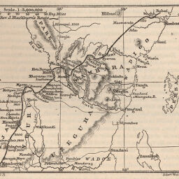
Country between Mombasa and Mamboia, East Central Africa
Permalink
https://digital.library.illinois.edu/items/293d0bb0-e946-0133-1d3d-0050569601ca-7
This item is in the public domain.
Descriptive Information
| Title | Country between Mombasa and Mamboia, East Central Africa |
| Creator | Ravenstein, Ernst Georg, 1834-1913 |
| Date | 1888 |
| Dimensions | 9.5 x 10.8 cm |
| Place of Publication | England |
| Cartographic Scale | 1:3,000,000 |
| Coverage-Spatial | Africa, Eastern |
| Genre | Maps |
| Language | English |
| Source | Proceedings of the Royal Geographical Society, V. 10, No. 2, p. 93. |
| Physical Location | rbx |
| Map No. in Bassett and Scheven Bibliography | 1318 |
| Call Number | 910_6RLn_s_ |
| Map ID | afm0001318 |
| Rights | No Copyright - United States |
| Rights Description | This item is in the public domain. |
| Collection Title | Maps of Africa to 1900 |
| Repository | Rare Book & Manuscript Library |
| Type | Cartographic material |
| Collection | Maps of Africa to 1900 |
Download Options
|
Country between Mombasa and Mamboia, East Central Africa |
Contact us
for questions and to provide feedback.